Our town gets started - Ellsworth began
in 1880.
(images without border may be clicked to enlarge)
Before Ellsworth existed, there were several settlements in the area,
that later led towards developing Ellsworth.
Click here --->  to learn about Callanan.
Click here --->  to learn about Lakin's Grove.
| There have been several theories as the the naming of Ellsworth.
It has been stated in several historical references Ellsworth was named
after a railroad official or surveyor who had helped to survey the right
of way through this territory. A son of this man confirmed to Henri
Fjetland that his father was a civil engineer who laid out the track from
the east. The plan was to have 7 miles between towns. Learning
that there was a railroad junction three miles west (Jewell Junction),
he questioned the location and put his name with a question mark where
Ellsworth was located. Another story is that the town was named Ellsworth
to honor the memory of Col. Elmer E. Ellsworth, of the Chicago Zouzves,
who was murdered in Virginia in the War of the Rebellion. One source
said that it was named for a railroad official, another stated that it
was named for an Iowa Falls banker. Some think this was the real
reason for the name, as it was confirmed in a book published by the Chicago
& Northwestern Railroad Company, which gave the reasons for the names
of all of the towns it created.
The town of Ellsworth was platted in October, 1880, by John I. Blair,
for the Western Town Lot Company, the real estate division of the
Toledo & Northwestern Railroad. Ellsworth is located in Section
30-87-23 of Lincoln Township and in Section 25-87-23 of Lyon Township.
It has a very close history to two other settlements: Lakin's Grove and
Callanan. This railroad town drew its population from these two early
settlement communities. The Callanan depot was moved to Ellsworth.
The next building to be moved into Ellsworth was the L. R. Bjelde Blacksmith
Shop, which came from Lakin's Grove.
The original plat consisted of eight blocks: four east-west and two
north-south. The streets running east-west were Decora, and Des Moines
Avenues. The streets runnng north-south were Delphi, Desota, Dewitt, Dayton,
Dearborn Streets. It is interesting to note that all seven streets
names started with the letter D. This did not happen in any of the
other Hamilton County towns.
A post office was established on Jan. 20, 1881, and is still in service.
It was located in the General Store, owned and operated by John Ringstad
and Chris Thoreson. This business was moved to Ellsworth from Callanan.
Ringstad became the first postmaster. He also served as the first
mayor and the first Justice of the Peace. |
|
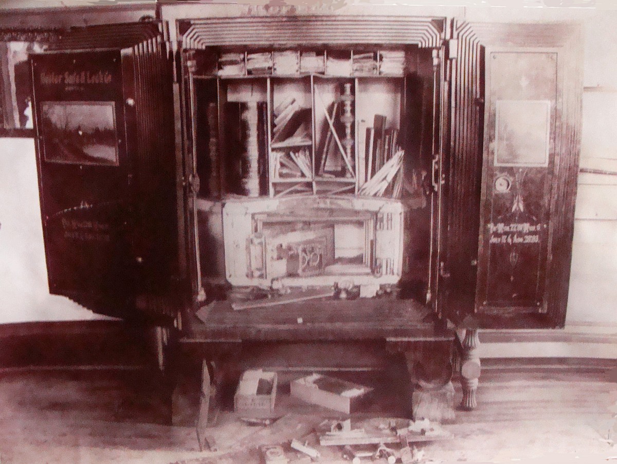
1898 Robbery of the State Bank of Ellsworth
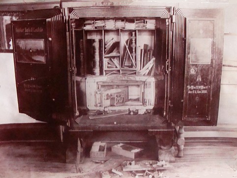
It was a hot summer night in 1898 that the State Bank of Ellsworth
was robbed of $1,500. The two well-dressed men who robbed the bank
had already eaten the evening meal with Mattie's family, the John Ringstad
family 3/4 mile south of Ellsworth. After visiting with the family
for a while, the men had rested in a nearby field until total darkness.
After robbing the bank, they caught the eastbound midnight train
to Gifford, Iowa. There they sought lodging at the hotel. After
the men had been apprehended, the $1,500 in a cigar box was found under
the bed. |
|
1898 Train Crash
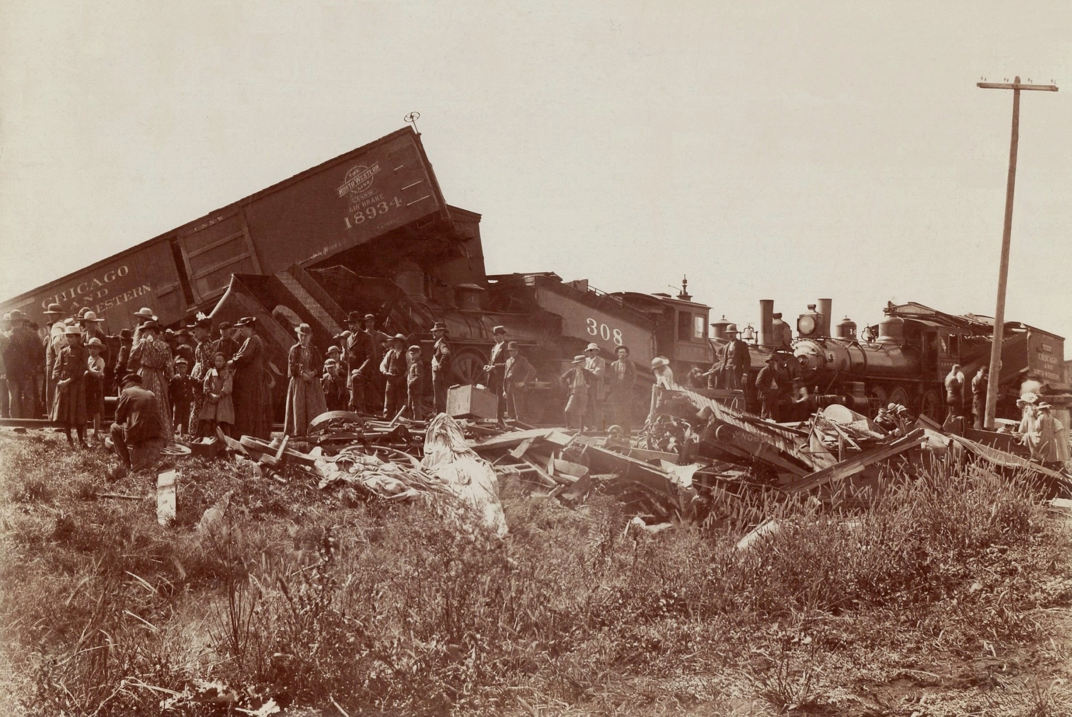
In 1898, two freight trains crashed together opposite the stock yards,
just east of the depot, piling up cars and tearing up the track.
One train was a double header and the other was being pulled by
one of the six-wheel drive locomotive, completely telescoped the freight
car behind it. |
|
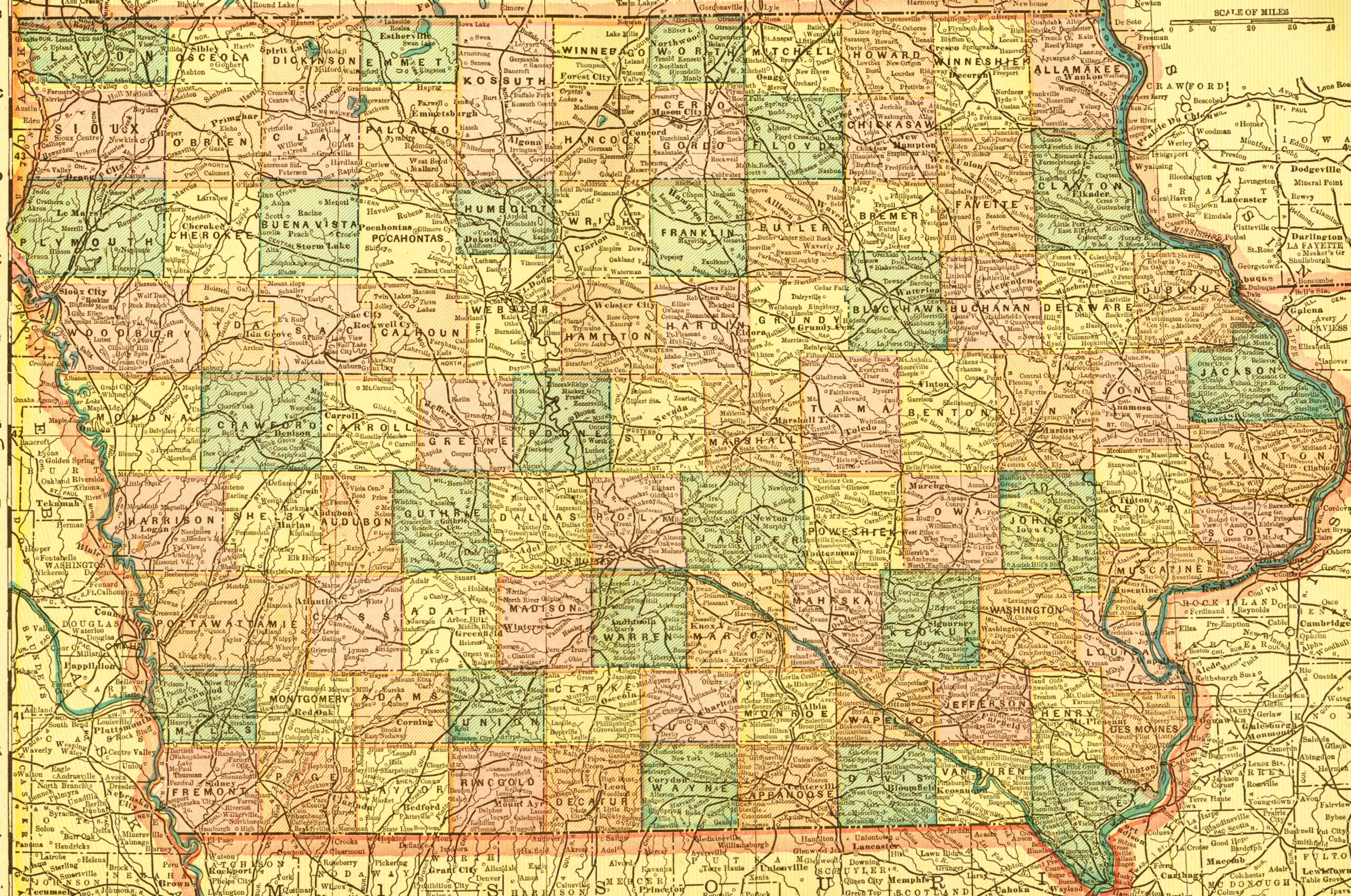
Ellsworth is seen on an 1899 Map.
here \|/
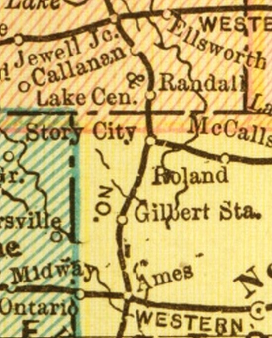
(Thanks to Ames Historical Society for this map) (Click image to
see entire map - 2mb)
This portion of the 1899 Crams Altas
showing Iowa railroads shows Ames (start at the bottom) connected North
through Gilbert Station, Story City, Randall, Callanan, and Jewell Junction.
Then to the East, one can find Ellsworth, nearly 20 years old at the time
of this map.
This map is not quite completely accurate, as Callanan was bypassed
and no longer on the railroad track at the time of this 1899 map.
20 years earlier than the date of this map, the railroad actually turned
east a bit to cross the Skunk River and go nearly one quarter mile up the
slope to enter Callanan. Three years later, the railroad curved a
bit west and no longer crossed the Skunk River because it headed to Jewell
Junction as this map shows. Perhaps this small error explains why
the map's "Callanan dot" looks west of the Skunk River. Notice
the vague colors and eliminated portion of the right side of the Callanan
dot and that unseen portion of the Skunk River. |
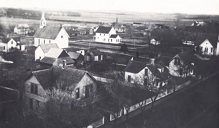
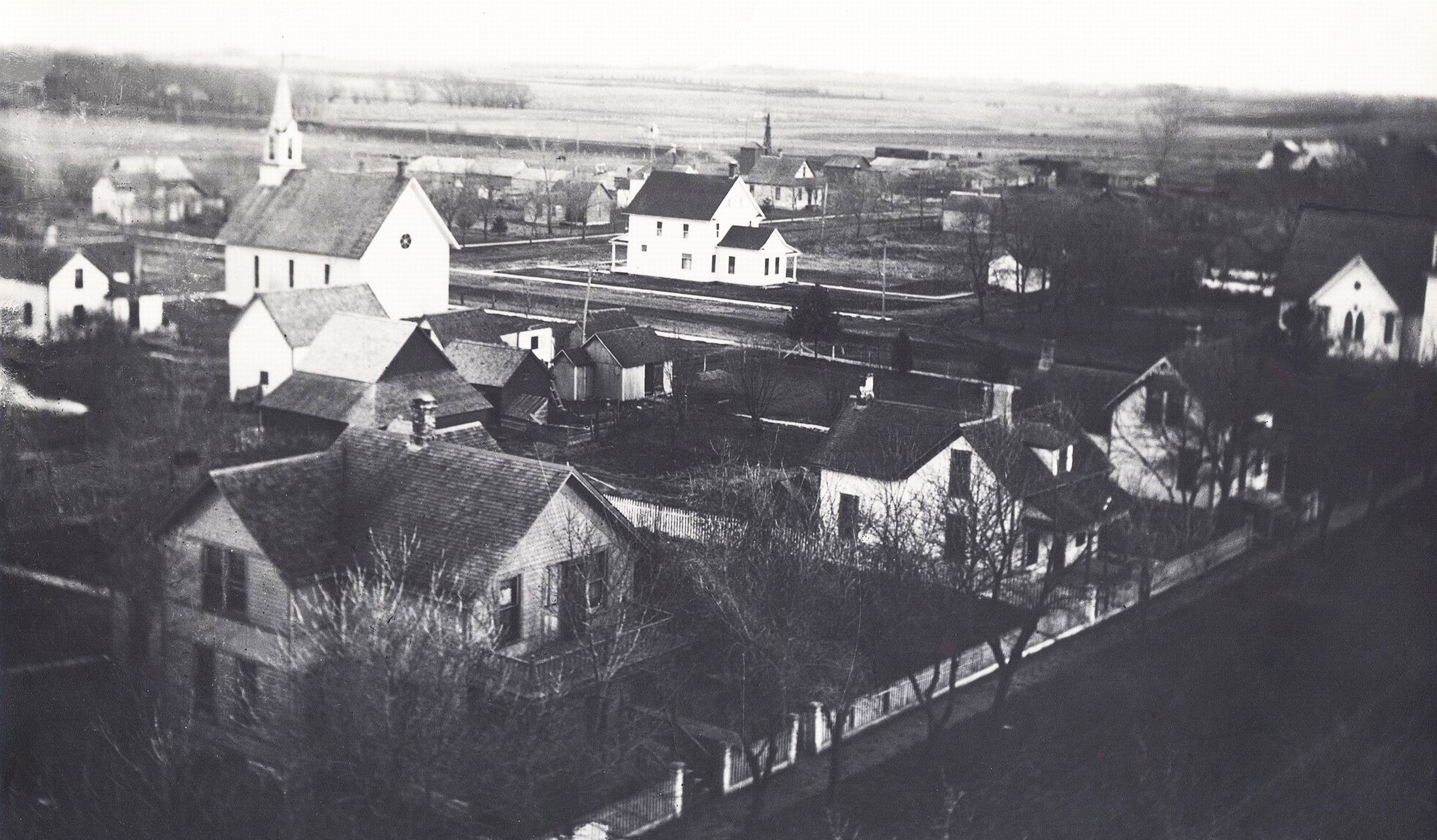
1900 - This is the first aerial view of Ellsworth,
Iowa.
The consus of 1990 showed a population of
396. The church building seen at left is the Methodist Church, built
in 1883. The church partially seen at the far right, was the Congregational
Church. Dayton Street visible at the left side, with DeWitt
at right.
Iowa Highway 175 is visible at the top of the image, and
the east-west street seen in the center of this image is Des Moines
Avenue.
The above photo was taken by Peter Holt
from the belfry of the Lutheran Church. The image was scanned in
1980 from an old glass plate negative.
Older homes still standing in Ellsworth:
1221 Delphi, built in 1900
1425 Delphi, moved to Fllsworth from Callanan in 1882
1519 Delphi, built 1881
1520 Delphi, 1893 from Callanan
1625 Delphi, built 1887
1621 DeSoto, built in 1900
1623 DeSoto, built in 1900
1519 Dayton, Business moved from Callanan, made into residence
1628 Dearborn, built in 1890
549 Hwy 175, built in 1880
546 Des Moines, built in 1900
436 Decora, built in 1900
|
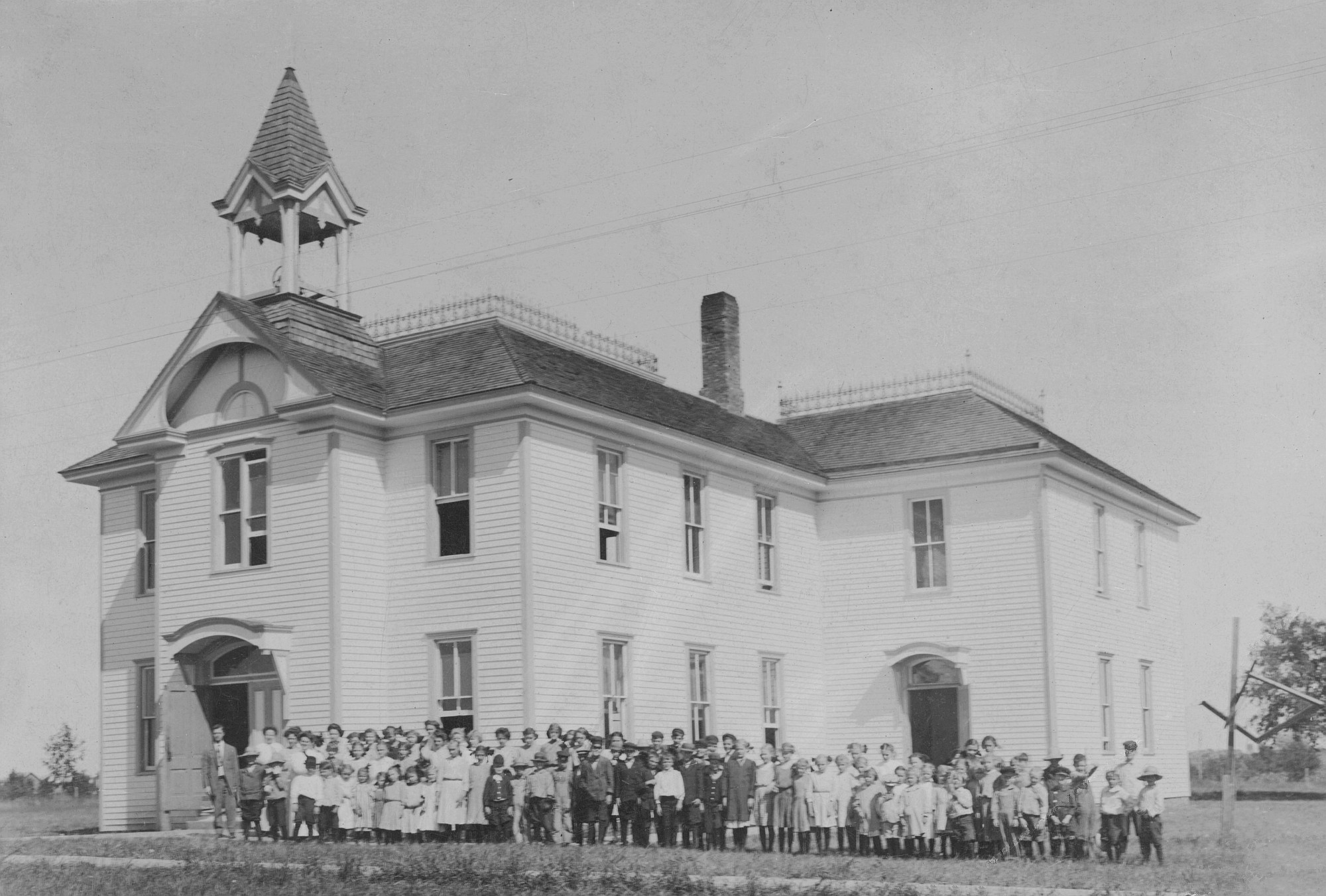
Starting in 1885 a
two-story frame school building was built to house the primary grades on
the first floor and the grammar grades on the second. The school
was enlarged in 1900 by the addition at the rear. This part was used
to house the upper grades. This building faced North and was located
just east of where Steve Holt's residence is now located.
See another photo of this early
school.
History Page (B)
back Home
|